Object-Level Modeling & Geospatial Entity Recognition
Standard 3D reconstruction produces a continuous mesh, one undifferentiated surface where a building, a road, and a tree are all represented as adjacent triangles with no structural distinction between them. This is sufficient for visual inspection, but it falls short for any application that needs to query, analyze, or interact with individual real-world objects.
Content-aware reconstruction goes further. By combining AI-based semantic recognition with instance-level segmentation, Get3D Mapper can extract individual geospatial entities from a 3D scene.
From “Image → Mesh” to “Image → Mesh + GeoEntity”
Standard reconstruction outputs one undifferentiated mesh surface. Buildings, roads, and trees are all adjacent triangles with no structural distinction.
Content-aware reconstruction adds two intermediate stages:
Object Extraction: Identifies and separates entity regions from the raw mesh
Individualization: Generates closed, independent mesh per instance
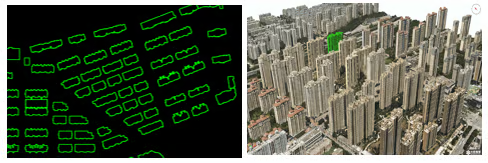
Result: Image → Semantics → Mesh + GeoEntity — each output entity carries identity.
Core Capabilities
- Automatically segments individual objects from oblique 3D models using entity boundaries.
- Detects and semantically models trees in 3D
- Filters out ground objects to generate DEM + DOM-based terrain representation
Application Case
GeoEntity recognition enables direct integration into domain-specific platforms. The following example shows a real estate information platform built on object-level 3D data:
- Click any building → query its semantic attributes (area, floor count, ownership, construction date)
- Property tables linked to 3D spatial positions
- Multi-source data fusion: 3D model + cadastral records + imagery
This is the practical output of moving from “a pretty 3D picture” to structured, queryable geospatial entities.
Related Articles
- What Is Content-Aware Technology? — Pipeline overview and paradigm
- Key Functions of Content-Aware Technology — Six key capabilities
- What is Large-Scale 3D City Modeling? — City-scale context for GeoEntity use
- What Is Satellite Imagery 3D Reconstruction? — Multi-source data integration
Source: Get3D Knowledge Center