What Is Spatial Intelligence? From Language to Worlds
Overview
Most AI we use daily reads text and labels flat images. Spatial intelligence is the next step: a system’s ability to perceive, understand, reason about, and act within three-dimensional space. In a widely cited 2025 essay, Stanford professor Fei-Fei Li framed it as AI’s “next frontier” — the move from language to worlds — and described the engine behind it as a world model: a system that is generative (it builds geometrically and physically consistent worlds), multimodal (it takes image, video, depth, text, even gesture as input), and interactive (given an action, it returns the next state of the world).
For teams working with 3D content — city models, digital twins, reconstructed scenes — spatial intelligence turns a model you can only look at into one you can talk to and operate on. Scholars describe the ultimate aim as answering the what, where, when, what-changed, why, and what-to-do of any place, then delivering the right information to the right person, at the right time. Spatial intelligence is the engine that gets there.
This article defines spatial intelligence through the three linked capabilities researchers use to describe it, the four traits that set it apart, and the agent loop where a tool like SpatialMind — built to take on spatial tasks in plain language — sits. (Note: this is the software capability — distinct from “spatial computing,” the AR/VR hardware that blends digital and physical worlds. You do not need a headset to use it.)
Why language models hit a wall
Large language models are fluent but, as Li puts it, “knowledgeable but ungrounded” — wordsmiths working in the dark. The limit is not eloquence; it is contact with the physical world. Even the strongest multimodal models:
- estimate distance, direction, and size no better than random guessing;
- cannot mentally rotate an object to a new viewpoint;
- cannot navigate a maze or pick out a shortcut;
- generate video that loses coherence within seconds.
They understand what was said, not how things relate in space, what they mean, and why they matter. Spatial intelligence is the capability that closes that gap — bridging imagination, perception, and action so a machine can perceive, reason, and act like we do in the real world. It is, in Li’s phrase, the “scaffolding of human cognition”: the ability that lets us park by judging a gap, catch a thrown key, or walk through a crowd without collision — fluidly, and in a way machines have not matched.
Three linked capabilities
Geospatial intelligence is commonly broken into three stages that feed one another:
- Perceptual generation — sense and generate. Turn raw observation (optical, radar, LiDAR point clouds, oblique imagery, vector data) into structured, locatable, temporally consistent geographic products. The point is not just pixel classification but embedding results into a scene: roads stay connected, buildings obey geometry rules, change detection aligns with administrative units.
- Cognitive representation — understand and express. Convert scene structure into computable, explainable, operable knowledge through symbols, language, and maps. The frontier has moved from image–text alignment toward models that reason over spatio-temporal processes — what connects to what, how it evolves, what fits where.
- Predictive decision-making — reason and decide. Move from “predict the outcome” to a decision loop: identify the problem, diagnose options and risks, select and execute the best action, then feed results back to improve the next cycle.
| Capability | What it does | Plain example | Where Get3D fits |
|---|---|---|---|
| Perceptual generation | Sense → structured geospatial data | Images become points, surfaces, and tagged objects | Reality-capture stage (aerial, ground, satellite) |
| Cognitive representation | Scene → computable knowledge | ”That cluster is a building; this corridor links two rooms” | The 3D reconstruction output itself |
| Predictive decision-making | Knowledge → actions | ”Flag everything outside the survey boundary” | The spatial-task agent (SpatialMind) |
The first two stages are about representing space correctly. The third is about operating in it — and that is where spatial agents earn their name.
Four defining traits
What separates spatial intelligence from generic “AI that handles geo data”:
- Human-like intelligence as the goal. The aim is cognition and decision quality that approaches a domain expert, not just automation.
- Spatio-temporal-semantic fusion. Space, time, and meaning are modeled together — a scene is never just geometry; it is “what, where, when, and why.”
- Hybrid, knowledge-guided computation. Knowledge, data, and models are co-driven: domain rules and expertise steer the model, not just raw parameters.
- Strong prediction and simulation. It forecasts how geographic phenomena will evolve from history and live state, and can replay “what-if” scenarios.
The agent loop: perceive, reason, act, evolve
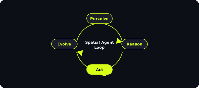
The leap from “a smart model” to “something you work with” is the agent. A spatial agent runs a closed loop:
- Perceive — fuse text, imagery, and sensor streams into a shared understanding of the scene.
- Reason — plan against a knowledge graph and the model’s reasoning, weighing options and constraints.
- Act — execute through specialized tools (queries, edits, exports) driven by a natural-language instruction.
- Evolve — learn from feedback, refining perception, decisions, and execution on the next pass.
This is exactly the layer SpatialMind is built for. It is not a simple spatial-data processing tool; it is an agent that takes a plain-language request and carries out the spatial task behind it. The agent loop is also why spatial intelligence is interactive rather than a one-shot detector — the system can hold a dialogue, not just return a label.
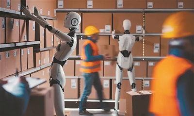
To make the loop concrete: a warehouse robot can re-route around shifting inventory instead of freezing when blocked; an autonomous vehicle can predict a pedestrian’s path instead of waiting for a clear signal; a digital assistant can read a gesture or the room you are in, not just parse a sentence. Spatial intelligence is what lets software move from passive analysis to active planning and adaptation — and it is built to enhance human judgement, creativity, and care, not replace them.
Why it matters for 3D content
Get3D’s reconstruction pipeline already produces the raw material — photorealistic, measurable 3D scenes from aerial, ground, and satellite capture. Spatial intelligence is what makes that material usable rather than merely viewable:
- Captured reality becomes queryable. Ask for what you need instead of hunting through a scene.
- Insight moves from dashboards to dialogue. Questions are answered in plain language, with the model doing the lookup.
- The same asset serves more people. Non-technical stakeholders interact with a twin without learning 3D software.
In short: reconstruction gives you the world in 3D; spatial intelligence lets you operate in it.
Related Articles
-
What is 3D Gaussian Splatting? — the representation that makes city-scale 3D viewable in a browser
-
What is City Modeling? — how captured reality becomes a city-scale digital model
Source: Get3D Knowledge Center